Building a 3D map of Kichwa territory in San Martín, Peru
07 Aug 2020
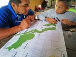
In 2019, CEPKA, FEPIKBHSAM, FPP and CAAAP set themselves the goal of mapping the main land uses in Kichwa territory in 3D. Specifically, they planned to map the area covered by the Cordillera Escalera Regional Conservation Area, with a view to demonstrating the ancestral presence of Indigenous Peoples in this region.