3D mapping process illustrates the value of nature and culture to sustainable livelihoods in Suriname
In the Wayambo River region of Suriname, the Konomerume community have produced the first ever 3D model of their customary lands, populated with information and stories about the important resources found in the forest.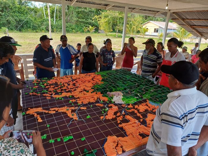
In the Wayambo River region of Suriname, the Konomerume community have produced the first ever 3D model of their customary lands, populated with information and stories about the important resources found in the forest.
They presented their map to government agencies and NGOs in February 2024, explaining how they see their territory, its value, what they do in it, what they need to sustain their livelihoods, and what threats they face that the government is not aware of.
The event led to a valuable inter-cultural dialogue on how the community would like the government to support them to protect their environment, and to enable them to live in harmony with nature.
The mapping process is being run primarily by VIDS, the Association of Indigenous Village Leaders in Suriname, with a Forest Visions grant secured by FPP.
The map is not the end goal; rather, it is an instrument for discussions in the community about the valuable resources on their lands. When painting the river, for example, they considered whether to include flood areas, and how they could use areas that are becoming drier or wetter as a result of climate change.
Schoolchildren, home from the city for the Christmas holidays, were surprised at how large the area is. It became visible. They saw the swamps they cross to go to the farming plots. They saw that the place where their fathers go to hunt is much further than they had thought. The map is raising cultural awareness.
The children were also trained to record their elders’ stories and through this process they discovered how much knowledge and work it takes to make a product from a forest plant. They became aware of the value in nature, and that not everything has to come from the shops in Paramaribo.
The community hopes to develop regulations that use the information they have captured to strengthen their inclusive decision-making process and customary land management.
Overview
- Resource Type:
- News
- Publication date:
- 1 April 2024
- Region:
- Suriname
- Programmes:
- Territorial Governance Culture and Knowledge Conservation and Human Rights Forest Visions
- Partners:
- Association of Indigenous Village Leaders in Suriname (VIDS) - Vereniging van Inheemse Dorpshoofden in Suriname
