Mapping Shared Territories in Practice: Baka and Bakwele communities use georeferencing to map key resources in the Republic of Congo
Baka and Bakwele communities in the Republic of Congo have spent a year documenting their daily and seasonal interactions with their territory using participatory methods and digital tools. The community members used GPS devices to georeference locations in their territories which contain key resources including specific plants and trees, ceremonial and spiritual places, water points and hunting and agricultural areas.
Through mapping how they interact with their environment, Baka and Bakwele communities can better share their common experiences, advocate for their rights, foster a sense of ownership and control over their territorial information and are able to inform policy decisions that affect their lives and livelihoods
From Data Collection to Community Validation
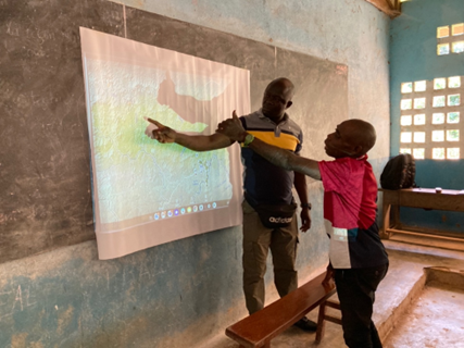
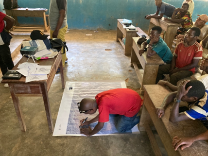
In October 2025, following a year of mapping, teams from CECD and FPP returned to the community of Adiala 2, to facilitate the validation of the outputs of this work with community members, reflect on what had been learned, and discuss next steps.
Separate meetings were first held for Baka and Bakwele community members to each review their maps; these were followed by a whole-village discussion during which all validated maps were overlaid and discussed collectively.
The maps combined:
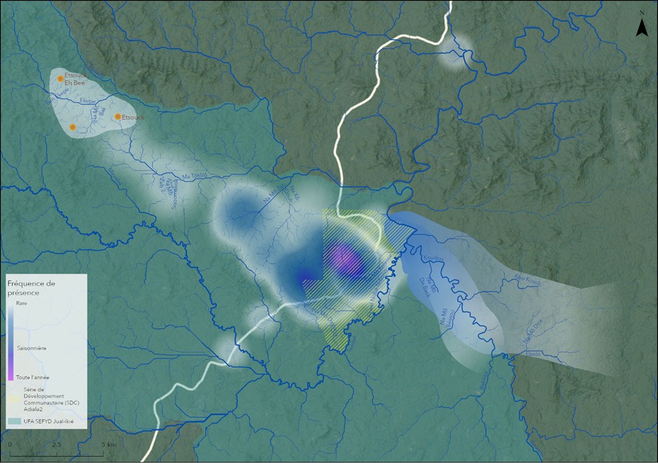
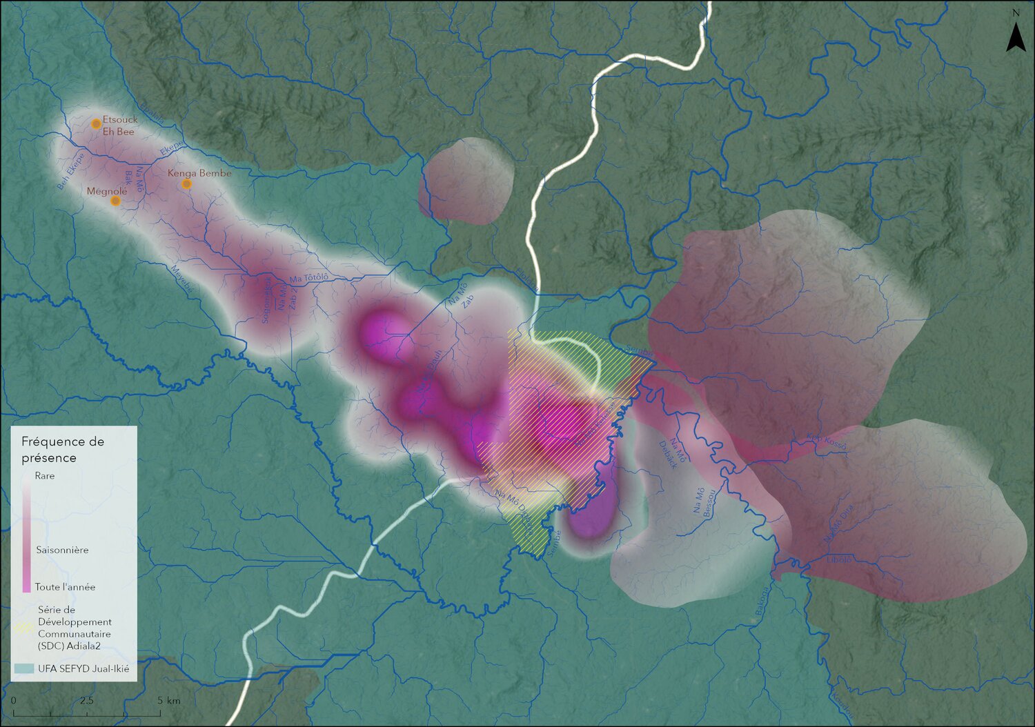
- Georeferenced points collected in the field, then weighted by frequency of use determined through discussions with different members of the community and represented as heat maps;
- Qualitative zones representing areas of regular activity, also weighted through collective discussions.
In both Baka and Bakwele meetings, participants confirmed that the final draft maps accurately reflected the areas they mostly used and frequented this year. Some corrections were made to river and other local names, underlining that the validation should itself be a learning process, which carries value and importance not just as a technical step, but because it offers moments of knowledge-sharing and correction led by communities.
Baka meetings were lively and detailed, with all groups and ages equally engaged in extensive discussion about different areas of the forest and how their use of it changes from year to year. Baka participants confirmed that they continue to use the entire territory, even if patterns shift seasonally and even annually, suggesting that a longer mapping period would likely reveal even richer and more complete data on patterns of relationships with the land and forests.
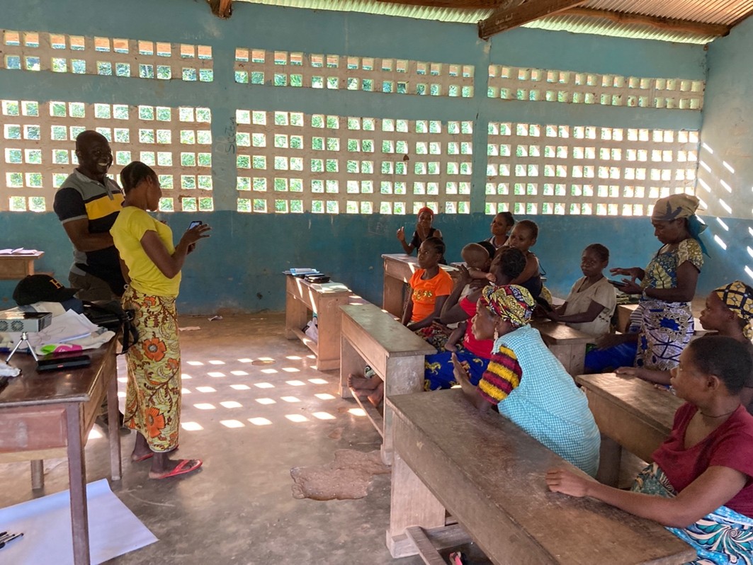
Bakwele discussions focused primarily on ensuring that areas closest and most relevant to their current livelihoods were clearly represented on their map; these included the rivers nearer the village, farming zones, and a key hunting area. There was comparatively less interest in discussing parts of Adiala 2’s territory more distant from the village: an elder woman noted that only a few elders now still hold a working knowledge of the deeper forest, and that this knowledge is gradually being lost among younger generations, who focus on cocoa production in nearby fields.
Overlapping Use, Shared Constraints
When overlaid, the Baka and Bakwele maps highlight the extent to which territorial use overlaps in specific portions of the village area.
After a year of working separately, both Baka and Bakwele expressed openness to sharing their maps with one another. While Baka participants had initially voiced a need for more frank discussions about cohabitation, in the joint meeting there was no overt contestation over territorial sharing. Instead, attention turned to shared challenges.
Members of both communities highlighted that the area available to them is too small for their needs, due mainly to the presence of and activities in the neighbouring SEFYD timber concession. Indeed, per its obligation in the Forest Code, SEFYD has set aside areas for community development (série de développement communautaire (SDC) within its concession for Adiala 2, but the community decry that this area is too small to accommodate their needs (see Figures 3 and 4). Meanwhile, in the production zones of the concession, where communities retain access and use rights, logging activities target tree species of high importance to local livelihoods.
Discussions also touched on shared responsibility for resource stewardship. One Baka elder raised concerns about declining wild yam yields, and linked this to harvesting practices that do not allow plants to regenerate. This sparked agreement across both groups on the need to protect shared resources through better collective management.
What the Mapping Revealed About Participation and Power
The mapping process itself produced important insights beyond the maps.
Community members showed generally more interest in the specific individual markers of places tied to particular activities or memories than in insights into differential frequency of use between Baka and Bakwele. The heatmaps were valuable in order to feed into national debates, and were built through a rich process combining quantitative visualisations with qualitative, place-based narratives.
That Baka do not have the capacity or capability to effectively document their own territories is a widely held preconception across the country, and one often voiced in policy debates. In Adiala 2, over the course of a year, Baka participants moved from having never used GPS devices to confidently collecting reliable geolocated data. Baka women in particular played a pivotal role in data collection. This is a direct challenge to such claims that Indigenous peoples lack the skills needed to engage in formal land documentation processes.
Feeding Evidence into National Policy Debates
As well as feeding into Adiala 2’s internal governance, preliminary results from their community mapping were shared in October 2025 at a national-level workshop in Kinkala, and later at the Brazzaville validation workshop. Convened to finalise proposed amendments to the draft decree intended to implement Indigenous land rights under the 2011 Indigenous Peoples Law, the workshops gathered civil society representatives as well as government and officials.
The work carried out in Adiala 2 helped inform discussions, particularly on the realities of shared territories. It helped to strengthen the provisions on cohabitation, providing concrete examples to inform discussions around participatory mapping, structured conflict-resolution mechanisms within the draft decree and clear definitions of cohabitation and differential mapping. Showing concrete evidence of Indigenous and local communities successfully documenting their own land use also helped counter resistance to stronger protections and participatory procedures in the decree.
As the decree continues through consultation and revision, the Adiala 2 experience offers grounded, practical evidence of why legal frameworks must account for overlapping land use, co-governance, and existing power imbalances within and between communities.
Looking Beyond the Maps
For the communities of Adiala 2, this mapping exercise was a first introduction to territorial mapping and monitoring, although not the end of the story. Baka participants expressed a strong interest in continuing to monitor specific shared resources, and will carry on with this work.
For CECD and FPP, this programme was a successful pilot as part of an ongoing partnership with Adiala 2, and a process we would like to build on and offer communities across the country, in support of their own journeys towards the recognition and respect of their rights. Feedback from Baka and Bakwele participants has clarified aspects that could further strengthen future initiatives, including longer mapping periods, repeated training sessions, and improved logistical support in particular for charging and maintenance.
Most importantly, Adiala 2 showed once again that when communities are truly considered as knowledge-holders and supported with appropriate tools, they generate robust, nuanced evidence about their territories. This evidence not only supports internal and local dialogue and shared governance, but also speaks directly to national and international policy processes.
As debates over Indigenous land rights continue in the Republic of Congo, the voices and maps from Adiala 2 remind us that effective solutions must start from lived realities on the ground, and be shaped by the people who know these territories best.
This article follows our earlier post, Mapping Shared Territories: A Collaborative Journey in the Republic of Congo, which introduced a mapping project started by the Baka and Bakwele communities living in the forest community known as Adiala 2. Having presented context, objectives and methodology, with this piece we share what the work has produced: validated maps, concrete insights into shared territorial use, and lessons that are already shaping policy discussions on Indigenous land rights in the Republic of Congo.
Aperçu
- Type de ressource:
- Actualités
- Date de publication:
- 18 mars 2026
- Région:
- République du Congo
- Programmes:
- Gouvernance territoriale
- Partenaires:
- Le Centre d’Encadrement Communautaire pour le Développement (CECD)
Actualités connexes
